DENSIFICATION ALONG TRAFFIC ROUTES IN UPPSALA
Following is a debate article I wrote 2014 about urban planning in Uppsala at the time.
Illustrations of my suggestion of an alternative plan can be seen in Urban Development Råbyvägen Uppsala in the Architecture category.
Since the Swedish city Uppsala is planning for an extensive expansion of housing development along central traffic routes in order to solve the problem of housing shortage, public transport and a too sparse urban space around the eastern traffic routes, there is a need to look at what architectural consequences this may have. This in addition to the aspects that have already been investigated on behalf of Uppsala Municipality. Below follows a discussion of various other possible effects such an expansion could lead to. The themes addressed are as follows: Residential streets as a structural category. The visibility of residential areas in the cityscape, visual transparency, the buildings as a catalogue of different periods, the combined effect of traffic separation and densification of routes, urbanity and the idea of filling in gaps in the city as a principle. The areas I refer to are eastern Uppsala, such as Kvarngärdet, Löten, Nyby, Gränby, Östra Salabacke and Årsta. This is a subjective study and is based on my own observations and reasoning.

Figure 1. Conceivable and current routes for densification
There is a very strong demand for housing in Uppsala and it is expected to increase more than the current pace of expansion. The policy is rather than expanding the urban area, one wants to densify within its borders. Then you look for undeveloped land in the spaces between the established buildings. Often you will find smaller pieces that are squeezed between two roads or between a road and demarcated already established residential areas. It has its origins in a few different factors: A newer urban planning ideology has taken over after the advent of, among other things. Uppsala's eastern residential areas. When these were built, it was considered important to have traffic separation. There would be a polarization between regional and local traffic movements. Newer currents, on the other hand, advocate a denser, cohesive network of streets and squares that prevailed before functionalism. There are four aspects in which the planning works: Traffic topology/network structure, spatial volume, functional disposition, façade expression.
In the development plans that have emerged in Uppsala recently, it is mainly within the aspect of spatial volume formation where the changes take place.
In urban planning today, the concept of urban healing is often used. This means "repairing" the torn otherwise continuous urban fabric by building in open spaces between separate clusters of buildings. Typically, this applies to environments created during the 60s and 70s housing construction in suburban areas. The aim is to connect isolated areas with each other, densify within residential areas to create a sense of inner city, counteract segregation by achieving a mix of tenancy forms and apartment sizes, achieve a mix of functions for local services, create a safe outdoor environment by the physical environment creating conditions for social control, get rooms with a larger population without allowing the city to spread out over the surroundings, create more profitable conditions for rational public transport while reducing travel milage by car. It is moving towards transforming the open, dissolved urban spaces that surround the major traffic corridors into denser, more like articulated city streets. In this development, there are aspects that still seem to be relatively unaffected in Uppsala. The traffic topology is still hierarchical, with a surrounding coarse network of thoroughfares and internal local streets with no possibility of through. The current functional disposition was further consolidated with more large-scale commercial areas outside the city centre in contrast to purely residential areas. A new large-scale retail area Gränby Köpstad/Brillinge is planned north of Gränby Centrum.
Traffic separation and densification of routes.
To find plots for housing construction in Uppsala, the spaces between traffic routes and parallel local streets have been used. In addition, in some cases, the traffic routes must be reduced to two lanes, provided they consist of four lanes.

Figure 2. Accessibility for cars in Uppsala
The traffic system in eastern Uppsala is designed according to principles such as separation and hierarchy. By car and public transport, it is only possible to get around the residential areas, not through, as in most cases are closed to through traffic by car. This means that there is a small proportion of regional traffic within the areas, which in that case takes place on foot or by bicycle, as opposed to a large proportion of local walking and bicycle traffic. Regional traffic occurs along the routes between residential areas. These areas are comparable in area size to the entire city centre, in some cases significantly larger.
According to the report Traffic Analyses Uppsala 2030 (included as a background report for Uppsala Municipality's comprehensive plan 2010), the total number of journeys will increase by 25% from 2008 to 2030, which corresponds to the estimated population increase of 40,000 inhabitants in the same time interval. Since there are long distances between the traffic routes and there are few roads to share the total amount of traffic of those who travel by car and public transport, there will be significantly more traffic of a through nature on these particular routes. The new homes will be located close to these intensive thoroughfares, which will strongly characterize the experience in these environments. Traffic on the local streets behind will also increase significantly due to the increased need for arrivals to the new homes between the streets.
In the past, there were factors in urban planning that limited the exposure of homes to traffic: Before functionalism, this was achied by allowing traffic to filter evenly distributed through the urban fabric. Since functionalism's hierarchically divided traffic into tree structures, homes were placed at long distances from thoroughfares. In addition, it was not uncommon to have open landscape spaces between the houses. Often they did not form street spaces, but rather they were in an unlimited space. Through the densification of the streets, the homes will be located directly against a road that also carries a concentrated amount of traffic. They are exposed to air pollution, noise and barrier effects. Noise can be protected against with the help of soundproofing windows and restrictions by not placing bedrooms facing the road. When you isolate the noise from the road, you also insulate against the sound of people from outside, which is not necessarily what you want. Through the planning's imposed restrictions on the apartment solutions, there is a risk that the living rooms will have to be turned towards the soundproof thoroughfare as a barrier instead of the perhaps more social side inwards in the residential area. In the city centre, restrictions are placed on car traffic along certain central streets due to local air pollution risks.
There may also be a need to investigate the possibilities and consequences of a future more fine-meshed traffic network through the eastern parts of Uppsala.
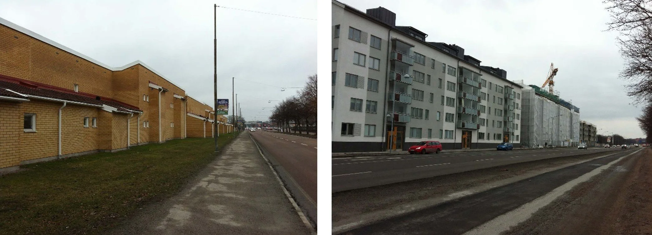
Figure 3. Different views on housing's close contact with traffic routes, 1980s (left) versus 2010s (right).
Residential streets as a structural category.
In terms of design, the closest equivalent to the emerging route development in Uppsala can be found in Luthagsesplanaden. It has roughly the same building heights and is also a traffic route. However, there are important differences that mean that you cannot just plagiarize the street space straight off: Luthagsesplanaden is part of a continuous development, Luthagen, which does not apply to the densifications of the streets. The width of the block along Luthagsesplanaden is usually much larger than, for example, along Råbyvägen through Kvarngärdet. In the latter, an attempt is made to apply an old model to a new situation, which would actually require the emergence of new models. The old model is not even fully used. By making half blocks, because whole blocks do not fit, you simply remove only a piece. The result is a U-shape closed towards the joint and open towards the back. Unfortunately, a situation arises with cut off mini-blocks. Hence the relatively small courtyards with enclosed balconies and squeezed in views from the corner apartments.
How can you link new homes that are laid along traffic routes to their close geographical context? When designing these, it is important that their outdoor areas are anchored with the outdoor areas of the existing homes, so that the new residents have a natural and easy access to a nearby recreational and social environment. Many of the new areas lack good conditions for a cohesive local affiliation with the surrounding buildings. The existing buildings enclose around their own courtyards and parks. It turns the hard side outwards towards what is now parking and a regional transport artery. The new buildings, if they stretch along the road like U-shaped narrow courtyards, are not capable of forming attractive courtyards, as there is not enough space adjacent to each one. The small yards are only good for playing areas for the youngest children. As they grow up and gradually need larger local areas, they are confronted with the distance to the slightly larger areas. These areas are also not accessible by views from the new houses. Since new buildings are now planned to be connected to this already defined outer boundary, there will be a connection problem to the existing one. How do you integrate the new into the old, which was built to be itself sufficiently? What is the possibility of the route to independently carry a context for the living environment?
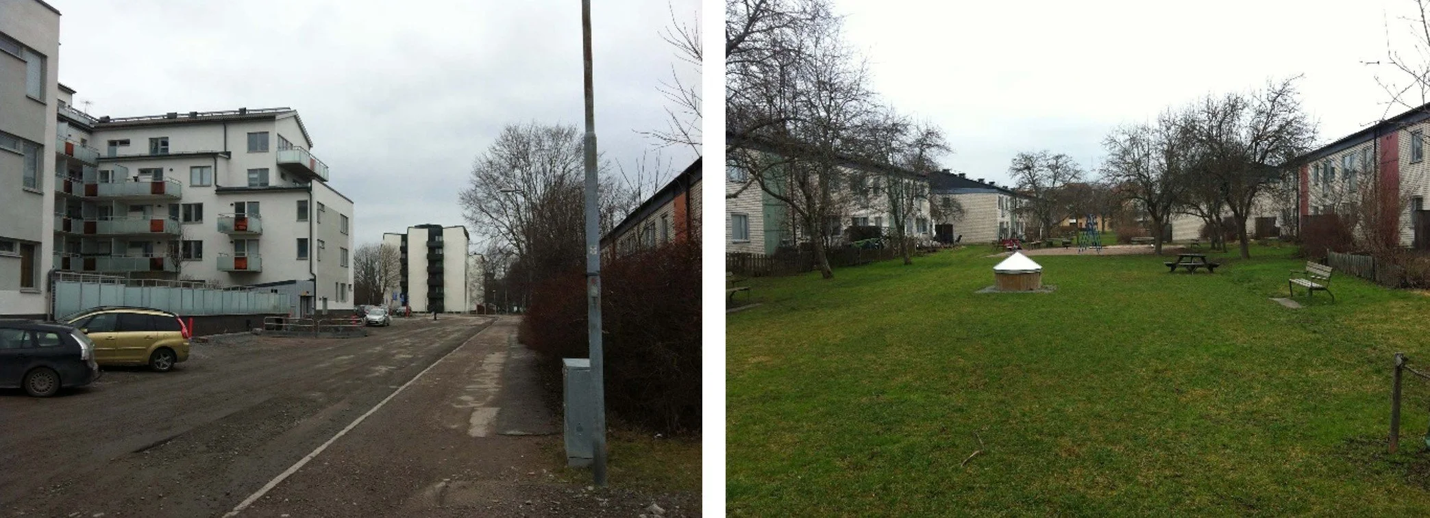
Figure 4. Example of barriers between the existing area and the additional street expansion that results in an Isolated courtyard with room for only one small playground (upper left in the left image) that has no contact with the park-like large courtyards in the existing residential area inside (right image).
The visibility of residential areas in the cityscape. Visual transparency.
Eastern Uppsala, as in so many other places, is composed of contiguous residential areas with a uniform building character. This applies to façade expression, materials, building volumes and spatial formation. These residential areas are clearly visible from the traffic routes. They are perceived as clear and separable units in the cityscape. You can identify a larger area based on what you see from the road. A map of the larger parts of the city is formed in one's mind. Between the areas run the linear traffic routes that connect Uppsala's different districts.
A typical feature of the buildings from the 60s and 70s is a simultaneous extension according to uniform patterns that extend from the adjacent traffic route and inwards approx: 150m to approx: 250m. The buildings meander in varying ways in a meandering finger structure with a courtyard on one side of the windings and access and access on the other side. Between two or more such forms of development, the courtyard side transitions into a larger continuous park area that unites all the surrounding courtyards.

Figure 5. Winding area boundary
Parking is usually on the periphery of the areas along the entire arrival side of the area. The car park is accessed from a local street parallel to the traffic routes. Along long stretches, there are three parallel roads with intermediate residual land. This residual land that surrounds the traffic routes is now in the process of being developed with housing. From the point of view of the transport routes, the existing residential areas will end up behind the new buildings. If the additional building stock is given a largely coherent form, the existing buildings will be hidden behind. In the traffic routes, people will travel along corridors enclosed in an elongated local/regional spatial context without a sense of the surrounding regional context in which they move. A discrepancy arises between the communicative movement and the visual experience. The previously so clear picture of the area division in Uppsala will be obscured by a covering drape. This results in a poorer ability to orient and a shorter readability horizon. In order to create a mental overall picture of the urban area as a regional whole, one must to a greater extent than before build a puzzle of various limited impressions and from an animated sequence along one's movement distance. What is missing in this process is the immediate large-scale images that make you build your mental map out of larger pieces.

Figure 6. Encapsulation of previously visible areas
The buildings as a catalogue of different periods.
The vast majority of the areas mentioned in this text were built during the Million Programme in the 60s. This applies to Gränby, and Löten, except for the Ling block, which was built in the 80s. Östra Nyby was built in the 70s. Southwestern Nyby was built in the 80s. Årsta was built in the 70s. Salabacke was mainly built in the 40s after World War II and in the 50s. Some supplementation has taken place in recent decades.

Figure 7. Main decade for expansion for a few areas.
The most recent decade of building design will not only be added to the designs of the earlier periods, but will even overshadow it. Previously, an area was built that covers an area that spreads in all directions. They thought area. Different contiguous areas represented a certain period of time. The buildings were formed according to a certain principle, which permeated the entire area all the way to the outer borders. There they transitioned directly to the next contiguous area. The different areas are directly adjacent to each other. Moving along the road between the area boundaries is like flipping through a picture book of the city's historical development. You can also move across directly from one contiguous area to the next, and thereby travel in history yourself. What is emerging today is a covering drape over a large part of history. The travelers of the future will instead stay on the same chapter in the city's historical picture book. The other periods will be glimpsed through small scattered holes in the blanket. Those who move across and through the areas will not be able to change environments directly without constantly passing through one and the same recurring time period, which constantly comes in and breaks the historical continuity.
The concept of Urbanity was put in relation to the expansion of Uppsala's traffic routes
The future densified Råbyvägen will make too much noise as an overly powerful corridor in the urban space. Like Luthagsesplanaden, it does not directly lead to a target point that corresponds to their spatial scale. The intersection with Svartbäcksgatan and Rondellen adjacent to Kungsgatan is certainly a traffic-important hub, but it is not a destination point for urban travel. This particular traffic hub is a strangely designed area because it connects three of the most important traffic routes into Uppsala while the street spaces have time to dissolve before this meeting. Here, the street space of all the intersecting roads should be extended as far as possible to form together with them a deliberately designed place with activities that make the contribution to the urban landscape that its basic characteristics deserve. Here, these roads do not only meet. It also coincides with the Fyrisån river and the north- and westbound railway branches. The overall situation makes the task of arriving at a strong overall solution in terms of design both extra urgent and complicated.

Figure 8. Luthagsesplanaden is monotonous and offers no activities on the ground floors. You only stay here if you are going somewhere else.
To design Råbyvägen's street space less demandingly, principles could perhaps be taken from the eastern part of Svartbäcksgatan north of Gamla Uppsalagatan. There are slats of houses that face the street, which opens up for joint glances deep into the area through several layers. The high, long and dense corridor builds up an expectation that you are really on your way to something truly urban. In the case of Luthagsesplanaden and to an even greater extent in the future Råbyvägen, it just leads on and away again. An important difference between these is that the cross streets of Luthagsesplanaden lead further into other areas and further again. It is thus integrated into the urban fabric. On the other hand, the vast majority of Råbyvägen's cross-connections from Väderkvarnsgatan and eastwards are local cul-de-sacs that do not provide opportunities for further travel in the street network or in the city as a whole. The only exception is Tycho Hedén's road.
To be called urban, which many people want it to be, it must follow the grammar of the city. If you build up expectations, you should also meet them, not cause confusion and disappointment. In the case of Råbyvägen, it should rather be called city-like. Today we have a unique situation with new conditions that are being tried to solve so far with answers that were used 70 years ago or more, for tasks and conditions that prevailed then. It resembles a kind of postmodernist superficial imitation at the level of urban planning. You pretend that you are building a city in the classic manner, but if you scratch the surface behind the facades, you find something completely different. The proverbial "urbanity" only reaches about 30m in from the main street, then it abruptly ends.

Figure 9. Svartbäcksgatan
However, several conditions from Svartbäcksgatan should be modified before its principles could possibly be implemented on Råbyvägen. This applies to the accessibility of the gables from the street and its function on the ground floor. Svartbäcken's house and its courtyards usually have a problematic relationship with each other, partly because the entrances are not throughout. The buildings on Svartbäcksgatan are from the 40s, Råbyvägen's buildings will probably be from the 2010s and should look like that.
Another street section affected by the ongoing densification is Vaksalagatan. It contains a number of other important factors that differ from Råbyvägen. Vaksalagatan begins with a significant transition from the countryside to the city over the crest of the hill Brillingevägen - Vaksala Kyrkväg. At Gränby Backe, a view opens up towards the cathedral, the castle and the landscape behind the city centre. You can see how the road leads all the way to Carolina Rediviva. The road takes the traveller directly into and through Uppsala's core with, among other things, Stora Torget and ends as Drottninggatan monumentally on a steep climb towards Carolina Redeviva. In the opposite direction from Carolina Redeviva you can see through the entire urban area. Vaksalagatan thus has better conditions than Råbyvägen to meet the expectations that a strongly articulated route gives to travellers. Vaksalagatan's important role in the urban fabric is also better explained than through a more toned-down appearance. Still, it is not a given that there should be a dense street façade along the road. The factors discussed earlier in the text, which concern the adjacent residential areas, also apply to Vaksalagatan, i.e. factors such as the relationship of the apartments to the street spaces on both sides, the relationship of the outdoor spaces to the surroundings, and the visibility of the areas and the history of the development.
About The idea of filling in the void in the city as a principle
The current strategy seems to be limited first and foremost to being a in-fill method. A long-term approach is to first establish a strategic overall situation and see what measures are required, and then use new buildings as a tool to realize the vision that has been aggreed upon. A short-term method is to start from the current shortage situation and use the city as a resource by drawing trails or finding voids in the buildings that can be plugged up, a bit like a landfill of leftover landfill.
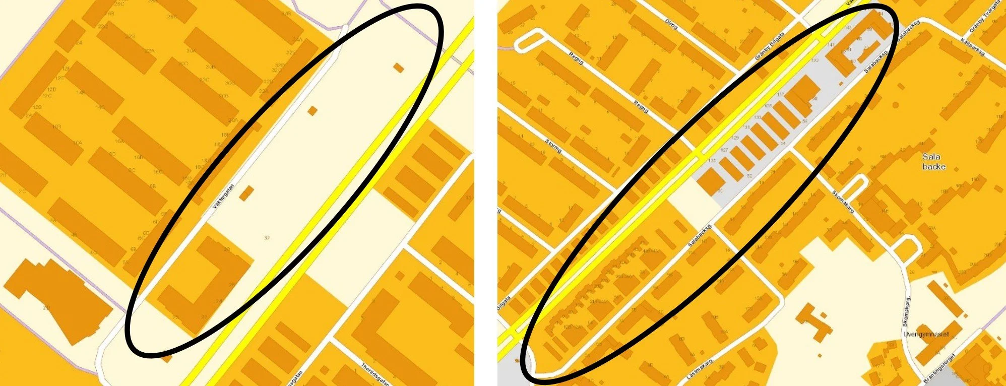
Figure 10. Two started condensation of the path.
By following the law of least resistance, one tries to solve a problem in the short term, which later risks entailing difficult limitations on future needs. If you want to create long-term functioning conditions, it is important to offer connection opportunities in the projects and opportunities to change them without having to destroy existing environments. Unfortunately, the 60s and 70s buildings in Uppsala do not offer obvious opportunities for connecting new buildings or measures in the traffic network. This puts current urban planning in a situation where a lot of energy will have to be put into the urban transformation, which will require a lot of resources and sometimes drastic measures.
It should be ensured that Uppsala consists of uniform, unified areas that are able to carry a context rather than reinforcing an emerging fragmentation of the cityscape, which is the risk if one establishes continuous residential streets that wall along the borders. At the same time, if the city's many internal peripheral areas are to be developed, a great deal of attention should be paid to issues such as the re-evaluation of traffic separation, fine-grainedness, housing in its urban context, the visibility of residential areas in the cityscape, the exposure of the local history of urban development and a consistent grammar in urban planning. Instead of routinely tinkering out these U-shaped half-blocks and trying to live up to old notions of what a city street means. Actually, an open architectural competition should be announced for a master plan for these routes, in order to generate new ideas. New solutions and principles may need to be invented. This problem is more complex and requires a greater familiarity with the conceptual process than has emerged so far.
In Sweden, we seem to be facing the largest and most dramatic transformation of our urban landscapes since the Million Programme. With great enthusiasm and a stormy consensus among politicians, architects, planners and construction companies, something that could almost be called the Million Programme 2 is being set in motion, and it is happening quickly. Before we know it, we are faced with a fait accompli, gazing out over a new reality with a dawning contemplation of eternally lost future possibilities.